GeoSens Training EO4IntDev
Online I September 19 – 23, 2022 I WürzburgPlease be kindly informed that the registration period for GeoSens EO4IntDev (September 2022) has ended.
Dear GeoSens participants,
we are very much looking forward to welcoming you to the GeoSens training.
Due to the increasing number of Covid cases and the risk that one positive participant during the training would lead to a cancellation of the whole training, we decided for the benefit of you and us to conduct the GeoSens again virtually.
We are aware that many registered participants of the GeoSens trainings would have preferred to participate in person and travel very long distances (e.g., from Iraq, Ethiopia, India) to Würzburg for attending the GeoSens training. We also would have preferred to have in-person training, however, due to the current situation, we decided to minimize the risk.
We regret not having the opportunity for in-person exchange but we will provide as many alternative meeting and discussion platforms as possible. All the more we build on and appreciate the potential of streaming and the great interest of all registered participants.
We in the GeoSens team would be very happy if you would stay with us and participate in the online GeoSens training for which you have registered (EO4IntDev in September and EO4QGIS in October 2022 and EO4GEE in February 2023).
We hope once more for your understanding.
Your GeoSens team
Data access & integration
Learn about Raw Data types, integrate them into your work and acquire theoretical knowledge
Hands on Exercise
Selection of data, software and processing platform with case study
EO applications in research projects
Gain insights into existing research projects through presentations by our specialists and discuss their contents
Please send your documents to the following email address:
“eo4intdev@uni-wuerzburg.de“
We will contact you with confirmation of your registration.
Integrating Remote Sensing in International Development Work
This training addresses beginners and is dedicated to the basics, analysis, quality assessment, and visualization of satellite remote sensing data using QGIS and Google Earth Engine. Monitoring and Evaluation (M&E) in the sense of derivation, analysis, and interpretation of time series are part of this training. The nexus of climate change – adaptation to climate change – land cover and land use – will be addressed in targeted examples and taken up in an exchange with the participants and the GeoSens team.
The training “Integrating Remote Sensing in International Development Work” (EO4IntDev) provides an overview of the potential of remote sensing with a focus on the analysis of satellite-based remote sensing data (such as Landsat, Sentinel, MODIS) and their applications, considering the basics, possibilities, and limitations in relation to the cooperation in international development projects such as those of GIZ.
During a total of five days, practical hands-on exercises for the implementation of a workbench (e.g., download of data, pre-processing, derivation of indicators and phenological indices, analysis, and interpretation) using open-source geospatial analysis tools such as Quantum GIS and Google Earth Engine will be provided along with theoretical knowledge.
Experiences from international projects in implementing remote sensing activities in project planning and international collaboration take a major role in this training. Lessons learned from the application of remote sensing data and methodologies in diverse projects will be presented and discussed in exchange with the participants.
The training EO4IntDev will be held by the GeoSens team, a non-profit training initiative run by a collective of researchers and experts from the Department of Remote Sensing at the Julius Maximilians University of Würzburg (Germany) and the German Remote Sensing Data Center at the German Aerospace Center (DLR). The EO4IntDev training takes place as a GeoSens Summer School and addresses interested persons with previous knowledge in spatial data (e.g., vector and raster data) who have ideally already worked with geographic information systems (GIS).
The training will take place in presence, hosted by the Department of Remote Sensing in Würzburg. Depending on the covid 19 pandemic situation and regulations, we would, if necessary, substitute the possibility of online training. In this case, the training will be provided online via the platforms MS Teams/Zoom. In case the training is held online, the GeoSens team seeks to provide the opportunity to meet virtually in smaller groups (breakout rooms) to ensure more detailed discussions and exchanges.
The participants of the five-day training will obtain a hard copy of the workbook for the GeoSens EO4IntDev training containing theoretical and practical (e.g., coding) information, and links to open-access data, and data portals. Furthermore, participants will receive a hardcopy of the book “An Introduction to Spatial Data Analysis: Remote Sensing and GIS with Open Source Software” by M. Wegmann, J. Schwalb-Willmann, and S. Dech (2020) introducing into spatial data analysis using QGIS and ‘R Project for Statistical Computing’ for gaining further hands-on for processing and analyzing spatial data, and their visualization.
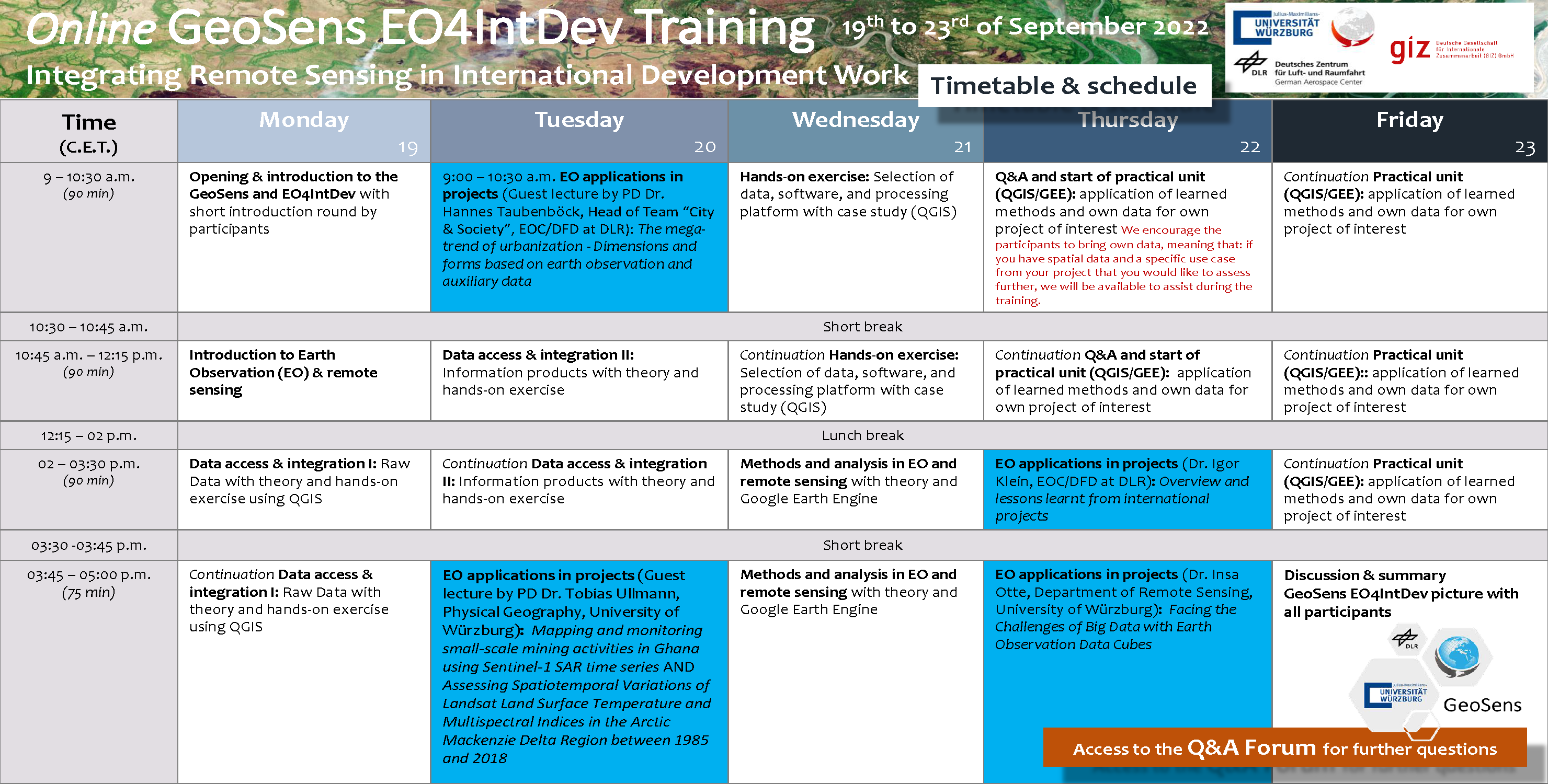
Training program for EO4IntDev in September 2022
Additional Information
| Type | Theory and practice |
| Goal | Enhancing the understanding of how remote sensing can support international development work and cooperation by gathering an overview of the potentials of satellitebased remote sensing data and their applications, considering basics, possibilities, and limitations in relation to the cooperation in international development projects such as those of GIZ. |
| Precondition | Persons already working or interested in working in international development work and cooperation with previous knowledge in spatial data (e.g., vector and raster data) and, in the best case, experience in working with geographic information systems (GIS). The nGeoSens team encourages the participants to bring their own data, meaning that; If the participant has spatial data and a specific use case from a project that could be assessed further, we will be available to assist during the training. |
| Duration | Five (5) days in an entire week with sessions in the morning and afternoon (a total of hours and 45 minutes per day) |
| Adds-on | Training material (i.e., workbook and note pad, installation guides for QGIS and Google Earth Engine, a hardcopy of “An Introduction to Spatial Data Analysis: Remote Sensing and GIS with Open Source Software” by M. Wegmann et al. (2020), access to the Q&A Forum hosted by the Department of Remote Sensing in Würzburg, exchange with participants and trainers in an international group, certificate of participation after completion of the training |
| Trainers | GeoSens team, a group of researchers and experts from the Department of Remote Sensing (University of Würzburg) and the German Aerospace Center (DLR), and guest lecturers on an invitation |
| Fee |
979.00 Euros Cancellations by participants up to 20 calendar days before the start of the training are free of charge. Please use eo4intdev@uni–wuerzburg.de for this purpose. For later cancellations, please also send a written request to eo4intdev@uni–wuerzburg.de. If no substitute participants can be named for cancellations at short notice up to 20 calendar days before the start of the training, the costs will be charged in full. |
| Next training dates | 19th to 23rd of September 2022 |
| Training capacity | 15 to 25 participants |
Be kindly informed that the arrangement of travel and accommodation in conformity with all rules and regulations (incl. in relation to Covid-19) is your own responsibility.
Got interested?
Get in touch with us!